01. History
In the early 1800’s, this area was logged for Red Cedar and Turpentine. The original grant was subdivided in 1880 (see below) and the blocks haven’t changed too much since then. In the late 1800s and early 1900s, this property was probably an orchard, like most farms in this area. In the mid 1980s, most of the land was still cleared, according to a previous owner. Later in the 1980s, the owners of Lots 3, 4, 5 and 6, subdivided into 3 blocks. Our property is the largest of these blocks (approx 4 acres).

02. Climate
Our property is close to the coast and the climate can be considered sub-tropical.
Chill units/hours: 700 (medium chill)


03. Constraints
03.01 Existing “problems”
Most of the property was still cleared 30 years ago. Due to neglect, some weeds have taken over:
- Coral trees (all cut now but stumps are still alive)
- Privet (good for stakes, toxic to goats)
- Lantana (soil builder, wildlife habitat)
- Morning glory.
- Wandering jew (good chicken food)
03.02 Legal constraints
The property is zoned 7a for conservation. This means that agriculture is not officially allowed.
The property is not officially prone to landslide, although some neighbouring properties on the Southern side of the hill are.
As most acreage properties on the hills, this one is prone to bushfire.
04. Personal objectives
- Self-reliance for vegies, fruits, poultry
- Trade excess food at FIG, LETS…
- No large animals (except goats, sheeps)
- Keep visible areas tidy and aesthetically pleasing
- Aquaculture system around the dam
- Potential home business: Bed & Breakfast, natural therapy practice, niche food market…
05. Major desired elements
- Kitchen garden
- Chicken coops
- Food forest
- Aquaculture in and around the dam
- More storage area
- Bee hives
- Compost
- Outdoor living area(s)
- Outdoor cooking area(s)
- Walking tracks
06. Site analysis
06.01 Areas
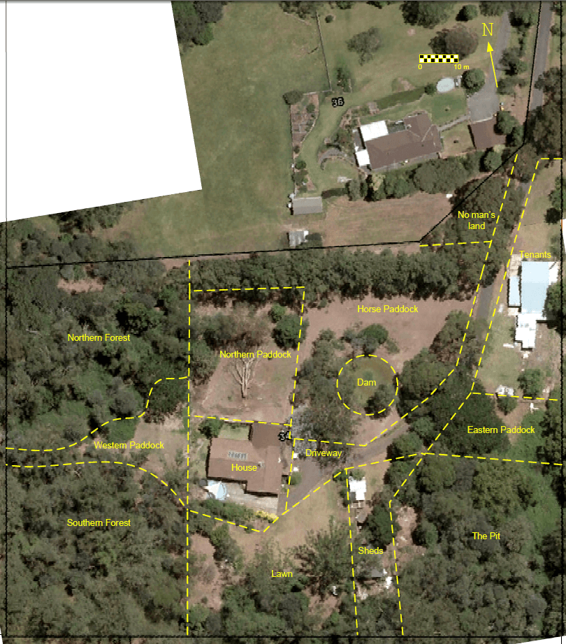
06.02 Structures
Note: the old house is out of scope and considered as a separate system
- House
- Garage
- Open shed
- Goat shelter
- Chicken coops
06.03 Topography

06.04 Water
Town water
The old house is connected to town water.
The water meter is as the bottom of the driveway, under the juniper. There’s a tap between the driveway and the “no-man’s land”.
Tank water
The new house is supplied exclusively by tank water.
The roof feeds the 2 concrete water tanks.
Water is pumped back to the house with an electric water pump. This means that during a power blackout, there’s no running water in the house.
06.05 Access

07. Sector analysis

08. Zones
Zone I
Kitchen garden on terraces behind the house (South) for intensive annual veggies
Perennial veggies in the garden beds, West of the house
Perennial veggies and citrus in garden bed, North of the house
Zone II
Improve the existing “orchard” to create a food forest on swales
Build a new chicken coop for layers, between the Zone I and Zone II, for pest control and easier egg collection.
Zone III
Rotate goats on a monthly basis between West paddock, North paddock and Horse paddock
Rotate the chicken tractor after the goats rotated
Swale in North paddock overflowing into the dam
Zone IV
Shelterbelt to protect from winds and fire danger from W-NW
Native tree forest for firewood, timber … And maybe nut trees.
Zone V
Mostly in SE area (very shaded and contaminated with rubbish)
Corridors around the property.

09. Proposed design – stage 1 (2012-2013)

09.01 New water tank(s)
Water supply to the house
Instead of pumping collected rainwater back to the house, we’ll install a Header Tank on top of the hill and feed water back to the house by gravity. We may install a small pump to provide extra water pressure for showers.
Rainwater collection
We have 2 options:
- Collect rainwater in the 2 existing concrete tanks
- Build a new collection tank behind the house (possible additional use for retaining) or in the West paddock.
Split collection between new tank and old tanks or spread the load?

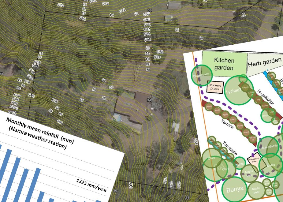
09.02 Kitchen garden
The slope behind the house is currently retained with a few large tree logs that are now very rotten and may collapse at any time.
We will add 3 tiers of terraces to retain the hill, provide garden beds and a pleasant sitting area.

Features:
- The lowest terrace will be supported by the existing sealed brick wall.
- The new terraces will be supported by dry stone walls, 0.6m high (batter not drawn below)
- Access:
- Ramp at the bottom, 1m wide
- Ramp at top near the new chicken coop and food forest, 1m wide
- Path : 0.9 cm wide to easily move a wheelbarrow around

09.03 Food Forest
We will improve the existing orchard to make it a resilient food forest.
The perimeter will be fenced off to keep wallabies, bandicoots, rabbits, goats, etc out, and to keep chickens in.
The 3 paths leading to the food forest will have a basic gate.
We will build a new chicken coop at the edge of the food forest and the kitchen garden. Sheltered behind the coop will be a plant propagation area.
New trees will be netted to keep birds out.
Irrigation polypipe will be connected to the Header tank and provide water in very dry weather.

Top swale:
- Located between wattle and 2nd gum tree
- No dig (poor shallow soil). The mound will be built with recycled green waste.
- Spillway on the North West end, to overflow into the terrace
- Trees: Mediterranean (dry tolerant) dwarf trees. E.g. Olive, Blueberry
Terrace:
- Located between the macadamia (uphill) and the 11th fence post (West paddock).
- Dining area with pergola behind the macadamia.
- If possible, level all the way. If not, slightly raise the dining area.
- Retained by a dry stone wall on the North West side.
- Filled with recycled green waste.
Access:
- Stairs along the West paddock fence
- Path from the kitchen garden to the pergola
- Path from the bottom of the hill, along the South end of the food forest.
- Spillway into the Hugelkultur
- Trees: Temperate dwarf trees
Hugelkultur:
- Stack logs and branches of (avoid allelopathic trees) on contour and over with recycled green waste
- Located between the Ice cream bean next to the mango and the lychee.
- Spillway on the South side into the bottom swale.
- Trees: subtropical dwarf trees
Bottom swale:
- Located near the blue gum tree (a few meters away) and the bird of paradise.
- Dig by hand or with a 5-ton excavator
- Spillway on the North side into the existing garden bed.
- Trees: subtropical dwarf trees (wind resistant species on North side)
09.04 New shed/garage
The existing open shed will be knocked down and replaced.
09.05 Other small structures
Beehives
We’ve built a terrace under the big blue gum next to the orchard. One beehive will sit on the big stump and another one will sit next to it on the terrace.

Firewood shed
We’ve built a 3.5×2.5m shed between the 2 blue gum trees, next to the orchard, to safely store firewood away from the house.
We’ll install gutters and harvest water in a 44-gallon drum.

09.06 Zone 0: the house
- Solar hot water system.
- Cladding on West wall: to reflect the hot afternoon sun and to protect in case of bushfire.
- Curtains on all windows
09.07 Shelterbelt
- We need to protect the house from W-NW winds and potential bushfire.
- We will plant a dense strip of wind-resistant and fire-resistant plants on the edge of the North forest and the West paddock. Plants will be as much as possible native and/or edible.
- Canopy (up to 30m): Silver wattle, Plum pine (Illawarra plum), Scrub beefwood
- Understory (up to 15m): Mulberry, Lilly Pilly, Sweet pittosporum, Cheese tree, Gosford wattle
- Shrubs: Breynia (Coffee bush), Sandpaper fig, native guava, banana
- Herbs: native ginger, pigface, native wandering jew.

10. Proposed design – Stage 2 (2014-)
Aquaculture in and around the dam
- Ducks
- Fish?
- Rice?
- Aquatic edible plants
Swale between the shelterbelt and the dam
- Low maintenance food forest
- Fire resistant semi-dwarf fruit trees
- Fodder trees
Food forest in East paddock
- Low maintenance food forest
- Semi-dwarf fruit trees